Paper Streets: An Opportunity for Trail Building
- Larz von Huene

- May 24, 2024
- 3 min read
Regional Trails Fellow, Larz von Huene, discusses the concept of "paper streets," which are planned but unbuilt streets marked on city planning and tax parcel maps. These streets offer potential for creating trails, providing an affordable and less intrusive alternative to traditional roads. This essay emphasizes the environmental and community benefits of transforming paper streets into trails, advocating for a greener, more accessible city where people can enjoy nature and connect with neighbors while walking or biking.
Using navigation apps every day, we can easily forget that street maps are not set in stone. Roads are closed, new roads are being built, and streets that have been planned for a long time have been pushed aside, forgotten except to parcel maps.
There is a certain kind of street, a paper street, that is in city planning documents but that ceases to be built, whether it be a lack of funding, need, or time. These “streets” are physically nonexistent but are still drawn in on city planning documents, and perhaps most importantly, tax parcel maps. They are “rights of way,” though they only situationally act like them, depending on the owners of the abutting property. Perhaps not surprisingly, one can quickly get into the weeds in this, with real estate law and historical assumed agreements coming into play, but overall, they present an exciting opportunity for connection between places where connection was meant to be.
Serving with Portland Trails, I was quickly introduced to this concept. Streets are expensive investments and require coordination, quite a bit of machinery, and might not be all that desired in certain areas. Trails, however, are cheap to build, are much less obtrusive, and benefit property owners nearby.
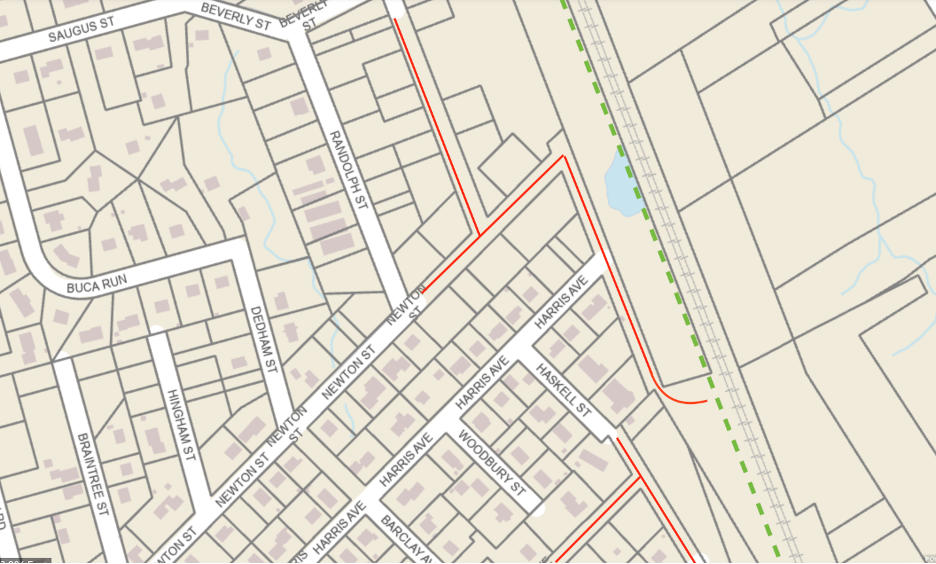
To better wrap your brain around this idea, a visual is helpful. Here is a screenshot from the Portland Tax Parcel Map.
You can see all the Paper Streets I have marked here in red. There are quite a few! Now imagine these as established trails. Suddenly, and at a low price-point, residents find it feasible to ditch their cars and walk out to the Riverton Rail Trail (green dotted line on map), which can take them all the way out to Morrills Corner. Wildlife is able to get out to the larger trail as well, staying away from busy roads that are dangerous to animals and drivers alike. Neighbors are connecting with each other, meeting up along the trail and coordinating clean ups for the trails they are proud of.
Paper streets provide an opportunity for trails to be built, especially in ways that serve the active transportation network of Portland. Vehicular traffic is one of the largest sources of carbon emissions in Maine, which can be understood by the lack of pedestrian infrastructure available. Building up the active transportation network will reduce the reliance on cars. As the densest city in Maine, Portland holds great potential for its residents to ditch daily car use and make a large impact on reducing carbon emissions in Maine as a whole. In order to do this, alternatives such as trails, bike lanes, sidewalks, and bicycle byways are a must. Paper streets present a great opportunity to make Portland an accessible and green city where people walk and bike to work amidst trees and wildlife. Forget sitting in traffic and replace it with resting on a bench in the woods!
About Larz

Larz grew up in Brookline, Massachusetts, where they grew a love of parks and plants. They attended Smith College, where they largely were involved in the Botanic Garden. They graduated with a degree in Biology and Landscape Studies and continued post-graduation to research atmospheric science and ecology in the White Mountains of New Hampshire. Living and working close to the summit of Mt. Washington, they spent a lot of time hiking and exploring the beautiful mountain trails. Outside of work, Larz likes to climb, make art, and do crosswords. They are excited to learn more about the planning, maintenance, and development of urban trails in their new position as Resilience Corps Fellow.


Comments